


Yuanjiajie
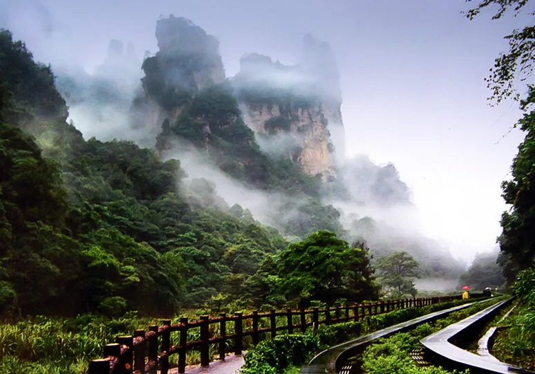
Yuanjiajie is located in the northern part of Zhangjiajie National Forest Park, with a total touring trail length of about 3.5 km and an average altitude of 1074 m. The entire route consists of flat flagstone paths without significant stairs, and a normal walking tour takes 1.5 to 2 hours. This area features the Bailong Elevator with a vertical height difference of 326 m, the “Southern Sky Column” (the prototype for the Floating Mountains) with a relative height of 150 m, and the “First Bridge under Heaven,” a natural stone bridge with a span of 50 m and a vertical drop of 357 m. This is the most concentrated area for observing the distribution of Zhangjiajie’s quartz sandstone peak forest landform.
Touring Route
The touring route mainly consists of a vertical ascent via elevator and a flat trail along the edge of the cliffs.
1. Vertical Ascent: Bailong Elevator
This is the primary mountain ascent route for most tourists. This fully outdoor sightseeing elevator has a total vertical height difference of 326 m.
- Structure: The bottom 156 m is a shaft carved inside the rock, while the top 170 m is a steel structure attached to the outside of the cliff.
- Operation Data: The elevator speed is 5 m/s, and a single trip takes 66 seconds. The maximum capacity of a single cabin is 50 people.
2. Landmark: Southern Sky Column (Hallelujah Mountain Prototype)
After exiting the elevator, take a 5-minute shuttle bus ride to the trail entrance. Walking about 800 m will bring you to the Southern Sky Column.
- Physical Specifications: This independent peak has an altitude of 1074 m, with a relative height of about 150 m from the valley floor to the peak.
- Morphological Features: Due to weathering and gravity collapse, the peak has a “top-heavy” structure. The top is covered with dense vegetation, while the narrowest part of the base has a diameter of only about 5 to 6 m.
3. Geological Formation: First Bridge under Heaven
Continue walking about 1.5 km from the Southern Sky Column to reach the First Bridge under Heaven. This is a naturally formed stone bridge spanning across the tops of two independent peaks 50 m apart.
- Dimensions: The bridge deck is about 2 m wide, 5 m thick, with a span of 50 m.
- Height: The vertical drop from the bridge deck to the valley floor reaches 357 m. The rocks that originally connected the two peaks at the bottom have collapsed into the valley.
Practical Travel Information
- Landscape Features: Typical quartz sandstone peak forest landform. The trail is built on the edge of cliffs, surrounded by deep valleys and dense stone columns.
- Expense Details: Included in the Zhangjiajie National Forest Park ticket for 227 yuan (valid for 4 days). A single trip on the Bailong Elevator costs an additional 65 yuan.
- Transportation: There is a shuttle bus station at the end of the trail. Heading north takes about 40 minutes to Tianzi Mountain, and heading west takes about 10 minutes to Yangjiajie.
- Clothing Suggestions: The 3.5 km trail is all flagstone; flat, non-slip shoes are required. Mountain temperatures are usually about 5 degrees Celsius lower than in the city, so a windbreaker is recommended.
- Precautions: Wild macaques often gather along the trail; keep your distance and do not rummage through plastic bags or feed them. The peak time for taking the Bailong Elevator up is between 9:00 and 11:00 am, with queues often exceeding 1 hour.
Tianmen Mountain
Tianmen Mountain has an altitude of 1518.6 m and is 8 km away from Zhangjiajie city center. The main landmark, Tianmen Cave, is 131.5 m high, 57 m wide, and 60 m deep, requiring a climb of 999 steps with a maximum slope of 45 degrees via the Stairway to Heaven. The scenic area is connected from the city to the mountaintop by a 7455 m long cableway with a height difference of 1279 m. The mountaintop features a 7 km cliff-hanging walkway, including 3 glass skywalks built at an altitude of 1430 m. The total walking distance for a single full tour is about 5 to 6 km, usually taking 4 to 5 hours.
The touring route of Tianmen Mountain is a closed-loop three-dimensional transportation system of “City-Mountaintop-Mid-mountain-City,” mainly composed of the super-long cableway, mountaintop trails, and the winding mountain road.
1. Vertical Ascent: High Mountain Passenger Cableway
- Operation Data: The cableway is 7455 m long, with a vertical height difference of 1279 m between the upper and lower stations. A single trip takes about 28 minutes.
- Capacity Specifications: There are 98 cabins in total, each carrying up to 8 people. The running speed is 6 m/s, with a maximum capacity of about 1000 people per hour in one direction.
- Visual Changes: The maximum climbing angle of the cableway reaches 38 degrees. The cabins pass over urban buildings, railway lines, and farmland before reaching the cliffs of the high mountain canyons.
2. Cliff Walkways and Glass Skywalks
- Structure: Most mountaintop trails are carved into vertical limestone cliffs of nearly 90 degrees. The three glass skywalks (West Line, East Line, and Panlong Cliff) are paved with double-layered tempered glass about 3 cm thick.
- Height and Dimensions: The glass skywalks are suspended at an altitude of 1430 m, with a single length of 60 m and a width of about 1.5 m. You can overlook the thousand-meter-deep canyon through the glass.
3. Tianmen Cave and Stairway to Heaven
- Tianmen Cave Dimensions: This is a naturally formed high-altitude mountain-crossing karst cave, 131.5 m high, 57 m wide, and 60 m deep.
- Stairway to Heaven Specifications: To reach Tianmen Cave from the plaza below, one must climb a total of 999 steps. The vertical height difference is about 150 m, divided into five gentle and four steep sections, with the steepest part reaching a 45 degree slope.
- Mountain Escalator: For those who choose not to walk, there is a total of 897 m of automatic escalators in 12 sections built inside the mountain to handle the passenger flow.
4. Descent Path: Winding Mountain Road (99 Bends)
- Road Data: The winding mountain road is 10.77 km long, with the altitude rising sharply from 200 m to 1300 m.
- Structural Features: Surrounded by steep cliffs, the road features 99 hairpin bends, with some having a turning radius of only about 15 m. The bus ride through this section takes about 25 minutes.
Practical Travel Information
- Landscape Features: Typical karst mesa landform with vertical cliffs, featuring a high-altitude mountain-crossing cave and the 99-bend road.
- Expense Details: The package ticket is 278 yuan (including entrance and cableway/bus). The mountain escalator is 32 yuan one way, glass skywalk shoe covers are 5 yuan, and the mountaintop chairlift is 25 yuan one way.
- Transportation: Three routes (A, B, C) are provided for two-way operations (determining the order of cableway and bus use). Both start and end at the lower cableway station in Zhangjiajie city.
- Clothing Suggestions: The average mountaintop temperature is 6 to 8 degrees Celsius lower than in the city; a windbreaker is required. Most paths are flagstone or boardwalks, requiring non-slip flat shoes.
- Precautions: In case of strong convection weather such as high winds or thunderstorms, the cableway will slow down or stop, and the glass skywalks will be temporarily closed.
Grand Canyon Glass Bridge
The Grand Canyon Glass Bridge is located in Cili County, Zhangjiajie. It spans across two mountain peaks with a main span of 430 m, a bridge deck width of 6 m, and a vertical drop of about 300 m to the valley floor. The entire bridge is paved with 99 blocks of triple-layered tempered glass, with a maximum single-time capacity of 800 people. A commercial bungee jump platform with a 260 m drop is located in the center of the bridge. The tour consists of crossing the high bridge and hiking at the bottom of the canyon. The canyon trail is about 3.5 km long, including cliff wooden boardwalks and boat rides, taking a total of 3 to 4 hours.
Touring Route
The touring route has a clear structure, consisting of the high-altitude glass bridge crossing, a vertical descent channel, and a flat hike at the bottom of the canyon.
1. Main Bridge Structure
This is the first project for visitors entering the scenic area, walking across the canyon at high altitude.
- Dimensions: The bridge is 430 m long and 6 m wide, with a relative height of about 300 m from the valley floor.
- Material Specifications: The bridge does not use conventional reinforced concrete piers, relying entirely on suspension cables at both ends. The walking area is made of 99 transparent triple-layered tempered glass blocks, each about 5 cm thick.
2. Vertical Descent Channel
After crossing the bridge to the other side, visitors need to descend from the 300 m mountaintop to the bottom of the canyon.
- Sightseeing Elevator: Most tourists choose the sightseeing elevator (Treasure Hunt Elevator) carved inside the rock wall. It has a vertical height difference of 120 m and takes about 1 minute, reaching the midpoint of the canyon quickly and saving energy.
- Assistant Slide: A 600 m granite slide is built in the middle of the trail, where visitors can slide down using gravity on a sliding pad, taking about 3 to 5 minutes.
3. Canyon Hiking and Water Transportation
After reaching the bottom, the style shifts from high-altitude views to waterside hiking.
- Valley Floor Trail: The 2.5 km trail along the stream consists mostly of flat preservative-treated wooden boardwalks and flagstone paths, accompanied by waterfalls and underground rivers. The hike takes about 1.5 hours.
- Boat Transfer: At the end of the trail is Shenquan Lake, where visitors must transfer to the free canyon cruise boat. The boat trip takes about 15 minutes, and the exit is reached upon disembarking.
4. High-altitude Extreme Projects
Several high-altitude project platforms are suspended below the middle of the glass bridge, mainly for tourists with specific interests.
- High-altitude Bungee Jumping: The platform has a vertical drop of 260 m to the valley floor, making it one of the world’s highest commercial bungee jump platforms.
- High-altitude Zipline: A 358 m long zipline with a height difference of 302 m is located on the side of the bridge, allowing visitors to glide from high altitude to the canyon floor.
Practical Travel Information
- Landscape Features: The first half offers a visual experience of a transparent suspension bridge 300 m high, while the second half features an enclosed canyon hike with streams and waterfalls.
- Expense Details: The Route B package (Grand Canyon + Glass Bridge) is 219 yuan. The sightseeing elevator is 30 yuan one way, and the bungee jump is about 2998 yuan per time.
- Transportation: Located about 20 km from the Wulingyuan Scenic Area. It takes 40 minutes by car or shuttle bus. A shuttle bus at the end of the tour returns to the visitor center.
- Clothing Suggestions: Flat shoes without metal studs are mandatory. Free non-slip shoe covers must be worn on the bridge. High humidity and waterfalls in the canyon suggest carrying a lightweight raincoat.
- Precautions: DSLR cameras, drones, walking sticks, and large luggage are strictly prohibited on the bridge (mobile phones are allowed). The bridge will be temporarily closed during high winds or thunderstorms.
Tianzi Mountain
Tianzi Mountain is located in the northwest of Wulingyuan District, with its main peak at an altitude of 1262.5 m and a total area of about 67 square km. Ascent depends mainly on a 2084 m long cableway with a vertical height difference of 692 m, taking 6.5 minutes one way. The mountaintop touring trail is about 2.5 km long, and a normal walking tour takes 1.5 to 2 hours. This area features the “Imperial Brush Peaks,” a cluster of stone pillars connected at the base and staggered at the top, and the “Fairy Scattering Flowers” peak with a relative height of about 100 m. It is the best location in Zhangjiajie to observe dense quartz sandstone peak forests and sea of clouds.
Touring Route
The touring route mainly consists of the cableway ascent, the mountaintop plaza distribution center, and walking viewpoints along the cliff edges.
1. Vertical Ascent: Tianzi Mountain Cableway
This is the main transportation for ascending and descending Tianzi Mountain, replacing a nearly 3-hour hike up steps.
- Operation Data: The cableway is 2084 m long with a vertical height difference of 692 m. A single trip takes about 6.5 minutes.
- Capacity Specifications: Each cabin carries 8 people at a speed of 5 m/s, with a maximum capacity of about 900 people per hour in one direction.
2. Landmarks: Imperial Brush Peaks and Fairy Scattering Flowers
About a 15-minute walk from the upper cableway station leads to these two adjacent major landmarks.
- Physical Specifications (Imperial Brush Peaks): Composed of dozens of staggered quartz sandstone pillars, the formation shows a “connected base and separated top” physical shape, with pine trees growing on the peaks.
- Morphological Features (Fairy Scattering Flowers): An independent peak about 100 m high. Its side profile, eroded by weathering, resembles the facial features of a woman.
3. Viewpoint: Helong Park
Located about 500 m west of the Imperial Brush Peaks, this is the largest flat distribution plaza on Tianzi Mountain.
- Facility Specifications: A 6.5 m high bronze statue of Helong weighing 9 tons stands in the center. The area includes commercial rest zones and public restrooms.
- Viewing Perspective: Several cliff-hanging viewpoints extend from the edge of the plaza, overlooking the West Sea peak forest valley with drops of several hundred meters.
4. Touring Time and Transfers
The mountaintop route is mostly flat flagstone paths with no major climbing required.
- Walking Distance: From the cableway station via Imperial Brush Peaks to the Helong Park bus station is about 2.5 km, taking about 90 minutes.
- Transfers: At Helong Park station, you can take a free shuttle bus to Yuanjiajie (40-minute ride) or Yangjiajie (30-minute ride).
Practical Travel Information
- Landscape Features: Wide views with stone pillars characterized by “slenderness, density, and height.” It is the highest and most expansive area among Zhangjiajie’s four major scenic spots.
- Expense Details: Included in the Zhangjiajie National Forest Park ticket for 227 yuan. The Tianzi Mountain cableway costs an additional 72 yuan one way.
- Transportation: The lower cableway station has shuttle buses to the Wulingyuan Sign Gate (15-minute ride). The mountaintop has buses to other mountain scenic areas.
- Clothing Suggestions: At over 1200 m, the temperature is 6 to 8 degrees Celsius lower than in the city; a warm jacket is required. High mountain winds make a lightweight raincoat preferable to an umbrella.
- Precautions: Some cliff trails may close due to ice after winter snow. High winds can slow cableway operations, leading to longer wait times.
Golden Whip Brook
Golden Whip Brook is located at the bottom of Zhangjiajie National Forest Park, featuring a 5.7 km flat canyon trail. The route runs from west to east, starting at Oxygen Bar Square and ending at Water Winding Around Four Gates. The altitude drop is only a few dozen meters, with no cableways or stairs. A normal walk takes 2.5 to 3 hours. Along the way, you can see the “Golden Whip Rock,” a 380 m high independent quartz sandstone pillar, and thousands of wild macaques. With a forest coverage of 98%, this is the lowest-intensity trekking area in Zhangjiajie, offering a valley-bottom perspective of the peak forest formations.
Touring Route
The touring route follows a linear structure along a flat flagstone path next to the stream, connecting various figurative stone peaks and wildlife gathering areas.
1. Canyon Flat Trail and Hydrology
This is the lowest intensity touring area in Zhangjiajie, traveling entirely along the valley floor.
- Road Specifications: The trail is 5.7 km long and about 2 to 3 m wide, paved with flagstones. There is almost no altitude change or steps.
- Accompanying Stream: The stream has an average depth of 0.2 to 0.5 m with clear water. There are more than 10 stone-paving crossings, taking about 150 minutes to walk the full length.
2. Landmarks: Golden Whip Rock and Eagle Protecting the Whip
About 1 km from the west entrance, the most representative independent peak of the area appears.
- Physical Specifications (Golden Whip Rock): This vertical quartz sandstone pillar rises 380 m high. It is steep on three sides and shaped like a four-sided prism, named for its resemblance to an ancient weapon.
- Morphological Features (Eagle Protecting the Whip): An adjacent independent peak that is slightly shorter, with rock textures resembling a mountain eagle with its wings half-spread.
3. Wildlife and Ecological Interaction Zone
The middle section of the trail and the area near Water Winding Around Four Gates are the main habitats for wildlife.
- Macaque Communities: Thousands of wild macaques live along the route, usually found on tree trunks or wooden railings 1 to 5 m from the trail.
- Vegetation: The canyon sides and floor are covered with Phoebe, fir, and other plants, with a forest coverage rate of 98% and high concentrations of negative oxygen ions.
4. Exit Transportation Hub: Water Winding Around Four Gates
The eastern end of the 5.7 km hike is a canyon basin of about 10,000 square meters.
- Geographical Intersection: This is the natural meeting point of four water systems: Golden Whip Brook, Suoxi Brook, Yuanyang Brook, and Kuangdong Brook.
- Transfers: There is a large shuttle bus hub. Heading north, it is 5 minutes to Ten-Mile Gallery, 15 minutes to Wulingyuan Sign Gate, or 5 minutes to the lower station of Bailong Elevator.
Practical Travel Information
- Landscape Features: A combination of flowing water and peak forests from a canyon-bottom perspective, offering an immersive forest walk without climbing.
- Expense Details: Included in the 227 yuan park ticket. There are no mandatory transportation expenses along the route.
- Transportation: The western start is about 500 m from the South Gate. The eastern end hub provides seamless connections to Bailong Elevator and Ten-Mile Gallery.
- Clothing Suggestions: Dense canopies mean short sunshine hours; temperatures are 3 to 5 degrees Celsius lower than on the mountaintops. Only lightweight sports shoes are needed for the flat path.
- Precautions: Strictly forbid carrying plastic bags or opening bags for food to avoid attracting wild macaques and risking accidental scratches.
Baofeng Lake
Baofeng Lake is located in Wulingyuan District, Zhangjiajie. it is a rare “lake in a high gorge” at an altitude of about 585 m. The lake is 2.5 km long, covers 30 hectares, has an average depth of 72 m, and a capacity of 4 million cubic meters. The tour consists of hiking and boating, taking about 2 to 2.5 hours in total. The area features the Baofeng Waterfall with a vertical drop of over 60 m and a suspended lake surface reached by a relative climb of 85 m.
Touring Route
The touring route follows a circular structure, passing through the valley-bottom waterfall, vertical hiking trails, high-altitude lake boating, and finally descending through a canyon.
1. Canyon Entrance and Baofeng Waterfall
This is the first area reached upon entering the park, a sunken valley floor and a major hydrological landmark.
- Physical Specifications: The waterfall is fed by the overflow of Baofeng Lake above, cascading down a steep cliff with a vertical drop of over 60 m.
- Film Background: This is the filming location for the “Water Curtain Cave of Flower and Fruit Mountain” where Sun Wukong jumps in the 86 version of “Journey to the West.”
2. Vertical Ascent: High Mountain Stone Steps
To get from the valley entrance to the mid-mountain lake, a physical climb is required.
- Road Specifications: The trail consists mostly of steep flagstone steps connecting the 500 m altitude valley floor to the 585 m lake surface, a vertical height difference of about 85 m.
- Data: A one-way climb takes about 20 to 30 minutes for someone with normal physical strength. For those less fit, a paid shuttle bus follows the winding road to the lakeside.
3. Water Sightseeing: Boating in a High Gorge
After reaching the mountain terrace, the tour switches from hiking to boating.
- Water Data: The lake is 2.5 km long, 150 m at its widest, and 72 m deep on average. The water comes from high mountain springs and rainfall, surrounded by hundred-meter-high quartz sandstone peaks.
- Boat Operation: Visitors must take the park’s unified painted wooden boats. A single loop takes about 30 minutes. During the trip, Tujia actors on small fixed boats will engage in folk song duets with tourists.
4. Descent Path: Cliff Walkway and A Thread of Sky
After the boat tour, visitors descend through another canyon path to the exit.
- Structural Features: The descent path is attached to the rock wall, passing through a natural geological fissure called “A Thread of Sky.”
- Dimensions: The canyon fissure is over 200 m long, over 100 m high, with an average width of less than 2 m, and the narrowest part only allows one person to pass sideways. The walk down takes about 30 minutes.
Practical Travel Information
- Landscape Features: The only independent scenic spot in Wulingyuan focused on water, shifting the perspective from “looking up at peaks” to “level views of water and mountain reflections.”
- Expense Details: Operated independently; not included in the National Forest Park pass. A package for adults (entrance + boat) is 62 yuan. Shuttle buses require an additional payment based on need.
- Transportation: Only about 2 km from the Wulingyuan Sign Gate. A 5-minute drive by car, taxi, or local bus.
- Clothing Suggestions: High wind speeds on the lake and temperatures 2 to 3 degrees Celsius lower than in the city require a thin windbreaker. Steep steps require non-slip sports shoes.
- Precautions: Stay seated during the folk song interaction; standing or shaking the boat is prohibited. Peak boating hours are 10:00 am to 2:00 pm, with waits potentially exceeding 1 hour.
Ten-Mile Gallery
Ten-Mile Gallery is located in the Suoxi Valley area of Zhangjiajie. It is a narrow canyon about 5.8 km long and only about ten meters wide. Currently, the touring trail and narrow-gauge electric train route open to tourists is about 2.2 km long, with no altitude gain, taking about 30 to 40 minutes to walk one way. The area features a linear structure with over 200 quartz sandstone figurative peaks, including the 80 m high “Herb Collecting Old Man” and the “Three Sisters Peaks.”
Touring Route
The touring route is very simple, a “one-line” round trip at the bottom of the canyon. Visitors can combine walking and the narrow-gauge small train.
1. Canyon Rail Transport: Sightseeing Small Train
This is the most recognizable mode of transport in the area, with tracks laid alongside the stream at the canyon floor.
- Operation Data: The narrow-gauge railway is 2.2 km long. The train runs at a gentle speed, taking about 10 to 12 minutes for a single trip.
- Carriage Specifications: The trains use a semi-open design. Each row of seats is equipped with a voice broadcast system that automatically explains the figurative peaks on both sides as the train moves.
2. Canyon Flat Trail: Flagstone Path
If you choose not to take the train, the trail is right next to the tracks.
- Road Specifications: The trail is also 2.2 km long, paved with a mix of wooden boardwalks and flagstones about 2 m wide.
- Walking Time: At a normal pace with stops for photos, a one-way walk takes 30 to 40 minutes, causing almost no muscle fatigue.
3. Visual Landmarks: Herb Collecting Old Man and Three Sisters Peaks
The quartz sandstone peaks have been weathered into distinct figurative shapes, with two being most prominent.
- Physical Specifications (Herb Collecting Old Man): Located in the middle of the route, it is an independent stone pillar about 80 m high. Its profile is highly tilted, with a top like a bamboo hat and a bulging back, visually resembling an old man walking with a basket.
- Morphological Features (Three Sisters Peaks): Located at the end of the 2.2 km route. These are three peaks about 100 m high, connected at the base and standing side-by-side. The left looks like a mother holding a baby, the middle like one carrying a child on her back, and the right like a pregnant woman.
4. End Point and Facilities
The end of the trail and track is a canyon clearing of about 2000 square meters.
- Animal Distribution: There is a fixed feeding point for wild macaques here, with dozens of them gathering around railings and slopes.
- Tour Turnaround: This is the physical end of Ten-Mile Gallery with no other exit. Visitors must return the way they came (walking or by train) to the entrance plaza.
Practical Travel Information
- Landscape Features: A level view of figurative peaks at close range from a narrow canyon floor, accompanied by the rail train.
- Expense Details: Included in the National Forest Park ticket. The small train is 38 yuan one way or 76 yuan round trip.
- Transportation: The entrance has a large shuttle bus hub. A 5-minute ride leads to Water Winding Around Four Gates (connecting to Golden Whip Brook or Bailong Elevator), and a 15-minute ride leads to Wulingyuan Sign Gate exit.
- Clothing Suggestions: Flat ground with no climbing; regular casual or sports shoes are fine. The canyon topography causes a wind-tunnel effect, making it feel about 2 degrees Celsius cooler than the park exterior.
- Precautions: During peak season, the queue for the train can be longer than the walk itself. It is recommended to walk one way and take the train the other way to balance energy and time.
Yellow Dragon Cave
Yellow Dragon Cave is located in Wulingyuan District, Zhangjiajie, featuring typical karst landforms. The cave has a total area of about 100,000 square meters, a length of 7.5 km, and a vertical height of 140 m. It has a four-layer structure of “two wet and two dry” levels, including 1 underground river, 4 waterfalls, and 13 halls. The tour uses a “water and land” mode, including an 800 m underground boat ride and about 2.5 km of stepped paths, taking 2 to 2.5 hours in total. It features the 19.2 m high stalagmite “Sea-settling Needle,” the most complex underground karst observation point in Zhangjiajie.
Touring Route
The touring route follows a one-way circular three-dimensional network, passing through the lower water levels and upper dry levels with large-scale step climbing.
1. Water Transport: Underground River Boating
After walking about 15 minutes into the cave, the tour switches to water.
- Hydrological Data: The “Xiangshui River” underground river is 2820 m long. The section open to tourists is about 800 m, with an average depth of 6 m and a constant temperature of 15 degrees Celsius.
- Operation Specifications: Visitors take battery-powered electric boats. A single trip takes 8 to 10 minutes. The channel is narrow, allowing only one boat at a time, and requires ducking under several low natural stone bridges.
2. Vertical Ascent: Heavenly Fairy Waterfall and Steps
After disembarking, visitors must climb from the level 2 water caves to the level 3 and 4 dry caves above.
- Step Specifications: The section from “Heavenly Fairy Bridge” to “Dragon King Cave” includes nearly 400 steps with a continuous vertical height difference of over 50 m, taking about 20 minutes and requiring significant physical effort.
- Waterfall Drop: On the climb, you can see the cave’s largest underground waterfall, “Heavenly Fairy Water,” with a vertical drop of 27.3 m from surface water collection.
3. Visual Landmark: Sea-settling Needle
Located in the center of the Dragon Palace Hall, this is the most complete stalagmite in the cave and the climax of the tour.
- Physical Specifications: It is 19.2 m high, 40 cm in diameter at the base, and only 10 cm at its thinnest part, showing a rare “thin ends, thick middle” structure.
- Growth Data: Geological calculations show it is mostly calcium carbonate, currently growing at about 0.1 mm per year. In 1998, the park insured this stalagmite for 100 million yuan.
4. Hall Space: Dragon Palace Hall
This is the highest and largest single dry cave space in Yellow Dragon Cave.
- Space Area: Total area is about 14,000 square meters (equivalent to two standard football fields), with a ceiling about 40 m above the path.
- Sediment Density: The hall is densely packed with over 2000 varied stalagmites, columns, and stalactites. Walking through the forest of stone takes about 15 to 20 minutes.
Practical Travel Information
- Landscape Features: A closed underground karst system. Observations of stalactites and underground rivers are assisted by artificial colored lighting.
- Expense Details: Operated independently; adult package (entrance + boat) is 121 yuan (not included in park pass). VIP no-queue channels with a guide cost an extra 98 yuan.
- Transportation: About 5 km from Wulingyuan Sign Gate. Take Bus No. 1 or a taxi from Wulingyuan; the trip takes about 15 minutes.
- Clothing Suggestions: Constant temperature of 16 degrees Celsius and near 100% humidity. Regardless of the season, a windbreaker is required. Wet steps require non-slip sports shoes.
- Precautions: Dim light and steep steps mean no taking photos while walking. Narrow boat channels mean no sticking hands out or standing up on the boat.
Yangjiajie
Yangjiajie is located in the northwest of Zhangjiajie National Forest Park, with a total area of about 34 square km and a highest peak at an altitude of 1130 m. The area features globally rare “quartz sandstone peak walls” where mountains are distributed in parallel bands. Single walls have relative heights of 100 to 300 m. Transportation depends on a 1876 m cableway with a 517 m vertical drop. The main trail is about 3 km long, including steep nearly 90 degree iron ladders and narrow rock fissures, taking 2 to 3 hours for a normal tour.
The touring route mainly consists of cableway ascent, traversing narrow mountain fissures, and vertical cliff climbing, following an original network of trails.
1. Vertical Ascent: Yangjiajie Cableway
This is the primary way to reach the mountaintop from the west gate of Zhangjiajie National Forest Park.
- Operation Data: The cableway is 1876 m long with a vertical height difference of 517 m. A single trip takes about 5.2 minutes.
- Capacity Specifications: 8-person cabins with a maximum speed of 6 m/s and a capacity of about 2000 people per hour in one direction.
2. Geological Formation: Natural Great Wall (Peak Walls)
A 10-minute walk from the upper cableway station leads to the Natural Great Wall viewpoint, a unique feature different from the “peak forest” landforms elsewhere.
- Physical Specifications: Dozens of quartz sandstone walls are arranged in parallel. Single walls are 100 to 300 m high, with widths of only a few to dozens of meters at the top, extending for several kilometers.
- Visual Features: The walls are sharp and steep on both sides, resembling a series of massive stone walls rising from the ground.
3. Steep Trails: Wulong Village and Tianbo Mansion
This is the most difficult and narrowest part of the Yangjiajie tour, preserving the precarious terrain of an early mountain fortress.
- Fissure Crossing (Wulong Village): The trail passes through three natural stone gates. The “A Thread of Sky” section is located in a fissure between two boulders, with a minimum width of only about 0.5 m. Adults must turn sideways and take off backpacks to pass.
- Vertical Climb (Tianbo Mansion): To reach the 360 degree panoramic platform of Tianbo Mansion, one must climb a steel ladder attached to a vertical cliff. The ladder is about 10 m high at nearly 90 degrees, allowing only one person to go up or down at a time.
4. Touring Time and Transfers
Due to the complex terrain, the trails have significant elevation changes and dense steps.
- Walking Distance: The round trip from Wulong Village to Tianbo Mansion is about 3 km. Due to terrain constraints, progress is slow, typically taking 120 to 180 minutes.
- Transfers: Shuttle bus stations are located at the upper cableway station or Wulong Village entrance. A 10-minute ride leads to Yuanjiajie, and a 30-minute ride leads to Tianzi Mountain.
Practical Travel Information
- Landscape Features: Unique band-shaped quartz sandstone peak walls. Trails thread through extremely narrow rock fissures and vertical cliffs.
- Expense Details: Included in the 227 yuan park pass. The Yangjiajie cableway costs an additional 76 yuan one way.
- Transportation: The lower cableway station has buses to the West Gate (Zhonghu ticket office), taking about 5 minutes.
- Clothing Suggestions: Climbing vertical ladders and passing through 0.5 m fissures require non-slip sports shoes. No skirts or large wide-frame backpacks are allowed.
- Precautions: The section from Wulong Village to Tianbo Mansion is extremely steep and narrow; it is closed during rain or snow. Not suitable for the elderly or young children.
Seventy-two Strange Towers
The Seventy-two Strange Towers is located on Wuling Mountain Avenue, Yongding District, Zhangjiajie, with a total building area of 110,000 square meters. The main building height is 109.9 m, certified by Guinness World Records as the world’s tallest Tujia stilted building. It uses a pure mortise and tenon structure with a giant gate 38 m high and 28 m wide carved in the middle. The tour focuses on nighttime immersive street walks with 162 guest rooms and nearly 200 local catering and intangible heritage shops. A normal walk and light show viewing takes about 1.5 to 2 hours.
Touring Route
The touring route follows a flat grid structure concentrated in the street area and main plaza at the base, making it a cultural and commercial complex that requires no mountain climbing.
1. Building Body and Giant Gate
This is the most direct visual object before entering the streets and the physical framework of the building.
- Dimensions: The main building is 109.9 m high, divided into several levels that restore the traditional Tujia “three intersections and nine rows” stilted building form.
- Gate Specifications: A hollow gate 38 m high, 28 m wide, and 21 m deep is in the center. This design of a large hole in a hundred-meter building is rare and mainly used for nighttime light and shadow projections.
2. Nighttime Light Show and Performance Matrix
This is the main content of the scenic spot, differing from natural scenery and relying on modern light and sound technology.
- Light Scale: Millions of LED lamps and holographic projection devices are installed on the facade and inside the gate, using the 109.9 m building as a screen for image projection.
- Performance Times: Large-scale light shows and plaza bonfires are mainly between 19:30 and 21:30. A single main light show lasts about 15 to 20 minutes, during which dozens of actors in ethnic costumes interact in the plaza.
3. Indoor Streets and Commercial Distribution
Entering the building from the plaza leads to the grid-like walking streets.
- Space Layout: The base streets include snack streets, bar streets, and heritage workshops with about 200 shops. The middle and upper layers house 162 themed guest rooms.
- Walking Distance: The street passages are flat and intersecting. Walking through the main shop areas covers about 1.5 km. Including time for eating and photos, a tour usually takes 90 to 120 minutes.
Practical Travel Information
- Landscape Features: A 109.9 m tall Tujia stilted building complex featuring nighttime holographic projections and Xiangxi market streets.
- Expense Details: Independent ticketing; nighttime tickets (after 16:30) are usually 88 yuan, and daytime tickets are 20 yuan. Catering and performance seats are charged separately at actual prices.
- Transportation: Located in Zhangjiajie city center, about 2.5 km from Zhangjiajie West Railway Station (a 5-minute taxi ride) and about 10 km from Hehua International Airport.
- Clothing Suggestions: Flat street walking requires regular casual flat shoes. Nighttime performances are in an open-air plaza; adjust clothing according to city temperatures.
- Precautions: Daytime visits mostly show only the exterior as many shops are closed. You must enter after 19:00 to see the complete light and performance system.
Keep Reading
- Zhangjiajie In-Depth 4-Day Itinerary | Golden Whip Stream Hiking + Tianzi Mountain Cable Car, Unlock Geomorphological Wonders from All Angles
- Deep Explore Zhangjiajie in 4 Days | Golden Whip Stream Hiking + Tianzi Mountain Cable Car, Unlock 90% of Landscapes Missed by Tourists
- Zhangjiajie 7-Day Ultimate Full-Landscape Tour | Tianmen Mountain / Grand Canyon / Rafting / Fenghuang, Complete Western Hunan Loop with No Regrets
- Zhangjiajie Photography Guide 4 Days | General Appointment Platform Sunrise + Imperial Brush Peak Sunset + Tianmen Cave Sea of Clouds, Best Shooting Spot Map
- Zhangjiajie Autumn 4-Day Leaf-Peeping Guide | Tianzi Mountain Colorful Forests + Baofeng Lake Reflections, Encounter the Peak of Colors
Zhangjiajie National Forest Park — Practical Information
Tickets & Booking
- Zhangjiajie National Forest Park (Wulingyuan core scenic area) single ticket: Standard ticket year-round CNY 165 each, with optional CNY 3 insurance, valid 4 consecutive days; concession ticket year-round CNY 83 each. Per the Hunan Provincial Development and Reform Commission “Notice on Matters Concerning Ticket Prices of the Wulingyuan Core Scenic Area” (Xiang-Fa-Gai-Jia-Fei-Gui [2024] No. 977), effective from Jan 1, 2025, valid 5 years; advance booking required (Timed and site-specific reservation entry is used; visitors are encouraged to use the “Zhangjiajie One-Machine Tour” WeChat mini-program for real-name reservation tickets and fast ticket-check entry)[src]
Transport & Schedules
- Inside the Wulingyuan scenic area → The various sights | Scenic-area eco-bus (included in the combined ticket/separate purchase): Eco-buses inside the scenic area connect the various zones; the high-platform touring lines at Tianzi Mountain, Yuanjiajie and Yangjiajie operate one-way loops, so plan to avoid backtracking[src]
Where to Stay · Room Type · Nearby
- Wulingyuan district (near the ticket stations) | Reference price Guesthouses/chain hotels about CNY 150–500 per night (reference) | Room tip: Close to the ticket stations, good for entering the park early and multi-day visits (the ticket is valid 4 days); conven | Nearby add-ons: Golden Whip Stream, Huangshizhai, Yuanjiajie, Tianzi Mountain, Yangjiajie, Ten-Mile Gallery, Xibu Street[src]
- Zhangjiajie city (Tianmen Mountain cableway lower station/Dayong Ancient Town area) | Reference price About CNY 140–550 per night (reference) | Room tip: If you also visit Tianmen Mountain, staying in the city is closer (the lower station of the Tianmen Mountain cableway is | Nearby add-ons: Tianmen Mountain, Dayong Ancient Town, Nanmenkou, Tujia Folk Customs Park[src]
Typical Climate & Packing (Past Years)
- January: 2.6 °C–9.4 °C °C, Zhangjiajie has a humid subtropical monsoon climate, humid and rainy
- February: 4.5 °C–11.5 °C °C
- March: 7.8 °C–15.9 °C °C
- April: 13.4 °C–22.7 °C °C, Spring is cloudy and misty, with a higher chance of cloud seas
- May: 18.0 °C–27.2 °C °C
- June: 21.6 °C–30.2 °C °C, Relatively high rainfall; watch for rain gear and slippery surfaces